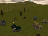
Colier View Hill: Difference between revisions
Jump to navigation
Jump to search
imported>Tlosk No edit summary |
imported>Arkalor No edit summary |
||
| Line 1: | Line 1: | ||
{{Settlement | {{Settlement | ||
| Name = Colier View Hill | | Name = Colier View Hill | ||
| Mansions = 0 | | Mansions = 0 | ||
| Villas = 0 | | Villas = 0 | ||
| Cottages = 8 | | Cottages = 8 | ||
| Apartments = 0 | | Apartments = 0 | ||
| Coordinates = 59.3N 40.9E | | Coordinates = 59.3N 40.9E | ||
| Nearest Town = Colier | | Nearest Town = Colier | ||
| Line 17: | Line 14: | ||
| Trophy Item 1 Qty = 1 | | Trophy Item 1 Qty = 1 | ||
| Provides Access To = [[Colier Mine]]<br>[[Olthoi Horde Nest]] | | Provides Access To = [[Colier Mine]]<br>[[Olthoi Horde Nest]] | ||
| | | Dereth Map = {{Map Point|Marker=Cottage|59.3|N|40.9|E|Colier View Hill}} | ||
}} | }} | ||
== Notes == | == Notes == | ||
* The [[Mattekar Hide Sleeves]] are crafted from a [[Small Mattekar Hide]] by a [[Leather Crafter]]. [[Mattekar Cave]] is a good place to hunt for them. | * The [[Mattekar Hide Sleeves]] are crafted from a [[Small Mattekar Hide]] by a [[Leather Crafter]]. [[Mattekar Cave]] is a good place to hunt for them. | ||
== Images == | == Images == | ||
<gallery widths=200px heights=200px perrow=3> | <gallery widths=200px heights=200px perrow=3> | ||
File: Live.jpg| | File:Colier View Hill Live.jpg| | ||
</gallery> | </gallery> | ||
Latest revision as of 02:14, 28 June 2015
| Colier View Hill | |
|---|---|
| Houses | 8 Cottages |
| Coordinates | 59.3N 40.9E |
| Nearest Town | Colier |
| Route | 26.3N 46.3E near Cragstone |
| Nearby Locations: | Colier Mine Olthoi Horde Nest |
| Purchase Costs | |
| Pyreal | 300,000 |
| Writ of Refuge | 1 |
| Mattekar Hide Sleeves | 1 |
Notes
- The Mattekar Hide Sleeves are crafted from a Small Mattekar Hide by a Leather Crafter. Mattekar Cave is a good place to hunt for them.


